CLASSIFICATION OF SPOTTY VOLCANISM ON EARTH: THE CONCEPT OF HOT SPOTS AND WARM SPOTS
by PETER SCHMIDT (C) 06 May 1996
short title: HOT SPOTS AND WARM SPOTS
ABSTRACT
Areas with volcanism that is intraplate or cannot be exclusively related to tectonical forces along plate boundaries (subduction, MOR) are considered. Volcanic provinces that can be explained by active support from the deep (mantle plume) are called hot spots. Regional swells capped with basaltic volcanism and/or progressively aged seamount chains suggest the identification of a hot spot. All volcanic provinces not identified as a hot spot and not related to subduction are called warm spots. They can be explained by the occurence of zones of weakness due to stress fields. The warm spot type can be subdivided into at least five classes, the riftogenic type, the continental intraplate stress type, the plume influenced type, the fault cluster type, and the oceanic intraplate stress type. The surface of the Earth can be subdivided into four types of regions with respect to the occurence of volcanic province types. The first region is characterized by the occurence of pure intraplate volcanism that can be explained due to mantle plumes or due to stress fields. The second region is characterized by the interaction of hot spots and rifting. The third region does not contain any hot spots but intraplate stress warm spots. The fourth region is characterized by the absence of hot spots and warm spots.
INTRODUCTION
After Wilson (1963) has introduced the term hot spot by the Hawaiian volcanism Morgan (1971, 1972) published a hot spot list of 16 and 20 hot spots, respectively. During the next years numerous additional hot spots have been identified. This "hot spot inflation" peaked in the extensive hot spot catalogue of Burke and Wilson (1976) which contains 117 hot spots. There are slightly modified versions of this catalogue in the literature (e.g. Vogt (1981) and Pollack et al. (1983)).
Mantle plumes are sublithospheric thermal anomalies that are assumed to be of convective origin. A typical shape of a mantle plume which has been derived by Courtney and White (1986) is depicted in Fig. 1. The mantle plume hypothesis is the currently most accepted explanation for a hot spot origin. A characteristic of hot spot volcanoes is their age-related construct in linear arrays, sometimes segmented, reflecting the movement of plates over stationary hot plumes.
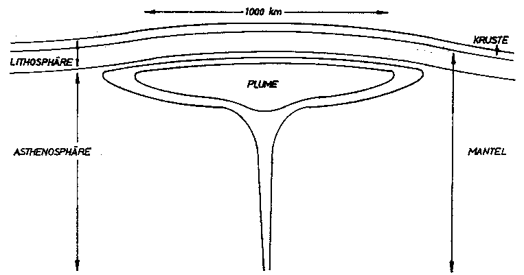
Fig. 1. Geometric shape of a typical mantle plume structure. Note the narrow pipe supporting the plume and the mushroom-shaped extension at the lithospheric base.
However, there are also quite different theories about the hot spot origin. Propagating cracks have been suggested by Turcotte and Oxburgh (1973,1976), Sleep (1974) and Solomon and Sleep (1974). Ubiquitous mantle heterogeneities are discussed by Sleep (1984). The reactivation of zones of weakness was presented by Sykes (1978). Localized shear melting has been proposed by Shaw and Jackson (1973). This list of alternative hypothesis is not complete. However, I follow White and McKenzie (1989) preferring active support from the deep (plumes) as hot spot origin. There are different structures of mantle plumes treated in the literature. These have been summarized and reviewed by Coffin and Eldholm (1994). See there for references on special types of plumes.
It is widely accepted to consider hot spot volcanoes as of mantle plume origin. However, it is not widely accepted to have more than 100 in part closely spaced hot spots of mantle plume origin. New catalogues of hot spots have been published that contain about 40 hot spot locations. One example is the catalogue of Crough (1983) that contains 42 hot spots.
Thus, there are two classes of catalogues. The first class contains about 40 different locations, the second about 120. Both show the concentration of hot spots in the Pacific and in the Afro-Atlantic area. The major differences between both types of catalogues concern locations in Africa and in eastern Asia. The larger catalogues list numerous individual hot spots within the African continent and a clustering of hot spots in eastern Asia. The smaller catalogues do not contain such a large number of African hot spots and do not show any hot spots in eastern Asia at all.
The first classification of hot spots has been presented by Wilson (1973) who distinguished among hot spots on or near the southern Midatlantic Ridge or the East Pacific Rise, on or near other oceanic ridges, geologically young hot spots and Rift Valley structures, geologically young hot spots in oceans that are assumed stationary, geologically old hot spots whose location of origin has been subducted. Furthermore, Wilson (1973) lists hot spots on triple points, fracture zones, large fracture zones and major fracture zones. A further description of different hot spot types is given in Sleep (1990) who points out that not all of the hot spots can be associated with mantle plumes. Several regions lack a topographic swell which is considered to be a surficial signature of a mantle plume. Marzocchi and Mulargia (1993) distinguish among three different types of a hot spot: sublithospheric origin independent of surficial tectonics, origin due to lithosphere with enhanced vulnerability, and anomalous magma production centers at midocean ridges.
LIST OF VOLCANIC PROVINCES
In order to give a hot spot list that is as complete as possible Schmidt (1994, 1996) compiled hot spot catalogues from various publications. Depending on the used definition of a hot spot
some catalogues contain locations that others do not list. In this study all hot spot locations mentioned in the literature are referred to as belonging to volcanic provinces. This term simply describes the observable surficial phenomena but does not refer to a certain origin. Volcanic provinces are defined as areas of volcanism that include intraplate volcanism and anomalous ridge volcanism. Fig. 2 contains the total of all volcanic provinces considered in the cited literature as a "hot spot".
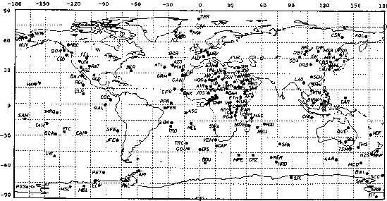
Fig. 2. Volcanic provinces according to a compilation of so-called "hot spots" identified in the literature. Most of these locations have been taken from Pollack et al. (1983). The list then has been completed by listings of the other publications cited in the text. Each dot represents a single identification locus.
Presentations of the distribution of volcanic provinces have been done in various manners. Geographical naming has been done by Wilson (1973) and Crough (1983). Geographical coordinate listings have been published by Pollack et al. (1983) and Richards et al. (1988). Most papers show a world map indicating "hot spot" locations by a dot. This kind of presentation have chosen Morgan (1971), Wilson (1973), Burke and Wilson (1976), Crough and Jurdy (1980), Vogt (1981), Pollack et al. (1981), Crough (1983a) and Pichler (1985).
Authors listed above who published their "hot spot distribution" by presenting a map with dots for a hot spot location neither have given reasons for the listed identifications nor have given a complete reference list. There are regions where the identification of volcanic provinces called hot spots by various authors is quite contradictionary. The coordinate listing of Pollack et al. (1983) contains several ill-defined locations where there are no volcanic features at all and has been revised in this paper by using the volcano list of Simkin and Siebert (1994).
Geographic naming of the volcanic provinces (Figs. 4 and 10) which are mapped as dots by Vogt (1981), Burke and Wilson (1976) and others has been taken from Thorpe and Smith (1974) for locations in Africa, and from Richards et al. (1988) for Atlantic locations. Additionally, the list of active volcanoes of Simkin and Siebert (1994) has been used for remote less known areas. A geographic overview of the active volcanoes listed by Simkin and Siebert (1994) is mapped in Fig. 3.
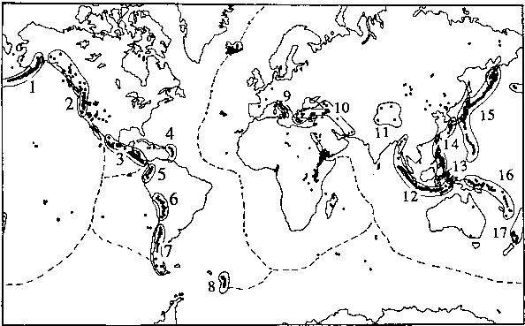
Fig. 3.
Geographical distribution of active volcanoes after Simkin and
Sievert (1994). A single dot refers to a single volcano
location. Clustering of volcanoes is indicated by unresolvable
single dots which mark the locations of plate boundaries. The
circled volcano clusters are provinces that are subduction
related. These are
1 - Alaska
2 - Northwest America
3 - Central America
4 - Caribbean Belt
5 - Northern Andes Group
6 - Central Andes Group
7 - Southern Andes Group
8 - Scotia Belt
9 - Italy excluding Etna
10 - Middle East
11 - Central Asian
12 - Indonesian Belt
13 - Moluccas
14 - Philippine Belt
15 - Japanese-Kamchatkan Belt
16 - New Guinean Belt
17 - Tonga-New Zealand
All these provinces are not discussed in this paper. The dashed
line refers to widely unknown individual activity along the mid-
oceanic ridges where activity often is documented indirectly
only. There are still lots of volcanoes located far away from
any clustering.
Numerous volcanic provinces depicted in Fig. 2 cannot be reconfirmed by the compilation of Simkin and Siebert (1994) who listed the volcanoes that are known to have being active within the last 10000 years (Fig. 3). Some of the provinces have been active in the past only (e. g. Bermuda after Detrick et al. (1986)). Thus, the classification in this paper represents the present state of a certain province. In the future, new provinces may occur, old ones reappear and others may disappear. The marked volcanic chains in Fig. 3 are associated with subduction processes. These are excluded from the consideration of this paper. Volcanism documentation of the oceans is incomplete (Simkin and Siebert, 1994) due to the limited access. Volcanism that is pure MOR-related (indicated by the dashed line in Fig. 3) is also excluded.
Figs. 2 and 3 represent two sets of volcanic data. In Tab. 1 those volcanic provinces are listed that occur within both sets. Additionally, the Pitcairn province is included due to the report of Stoffers et al. (1990). Thus, the spots listed in Tab. 1 are considered as being in a recent hot age and accepted as volcanic provinces that qualify for being classified in this study. In addition to the volcanic provinces documented active by Simkin and Siebert (1994) selected other provinces are included in the classification. These additional provinces have not (yet) documented as being recently active. They have been considered in numerous publications as a "hot spot" and have
been frequently investigated. Tab. 2 lists these selected provinces. Some of these volcanic provinces must be considered extinct. However, most of them simply lack a known site of recent activity or have been documented active in Cenozoic or even Quaternary times, but not recent. All provinces that have been documented active at least in the Quaternary qualify for being considered as dormant spots. These are also included in the classification.
DEFINITIONS
The main target of this paper is to distinguish between volcanic provinces that are caused by active sublithospheric support from the deep and those that may be caused by passive support originated from any kind of regional stress interactions within the lithosphere. Classifying objects means to put them into a certain kind of order. Each object to be defined and then classified will be different from comparable objects of the same population. Due to interaction processes some objects could have been put into more than only one class. Closely spaced volcanic centers have been put into one province. Thus, a dense province concentration which is visible e. g. around Cameroon in Fig. 2 is depicted in Fig. 4 as one province if a relationship between the single edifices is evident.
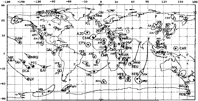
Fig. 4. The geographical distribution of hot spots (marked by dots and larger letters) and warm spots (marked by crosses and smaller letters) listed in Tabs. 1 and 2. Extinct provinces (see text and Tab. 2) are excluded. Hot spots are shown by large dots surrounded by a closed line that defines an approximate geographic surficial interaction extension. Hot spots that have been questioned (see Tab. 2) to be extinct are shown by a point surrounded by a circle. Warm spots are indicated by crosses surrounded by closed lines. The crosses refer to a reference volcanic edifice of the province which is defined by the surrounding line. Tracks (progressively aged chains of islands/seamounts) are indicated by a single line. An "F" refers to a flood basalt province as the origin of a track.
Hot spots of mantle plume origin (HS)
Definition 1: A volcanic province is identified as a hot spot if active sublithospheric support (mantle plume) is claimed to be its origin.
After White and McKenzie (1989) the existence of well-defined hot spot tracks is evidence for plumes. This is especially true in the case a track crosses a mid-oceanic ridge. Tracks of crack origin would be expected to stop when reaching the free edge of the ridge axis. Furthermore, excessive volcanism along break-up margins is evidence for plumes (White and McKenzie, 1989).
The observation of mantle plume originated structures at the surface is constrained by the fact that this requires the plume signature has penetrated successfully the lithosphere. The sublithospheric arrival of active support from the deep will not automatically result in volcanism at the surface. Energy will be consumed while the plume interacts with the lithosphere. Thus, only persistent support from the deep may result in a surficial hot spot expression. The amount of volcanism will depend on both the power of the plume and the state of the lithosphere. A cracked and/or thin lithosphere of course will be more vulnerable to a plume than a thick and/or uncracked lithosphere. However, due to the requirement of a persistent support always a regional area will be affected. Thus, there will be a minimum size of a hot spot of about 1000 km in diameter. The observable phenomenon that outlines this extension is the regional swell.
The existence of a regional topographic swell is a necessary criterium for a volcanic province to be identified as a hot spot location. Hot spots are often located totally intraplate (IP) but can be also located on-ridge (OR) (or off-ridge in close vicinity to the ridge). For there are swells of different origin the swell will be not a sufficient criterium. The hot spot center must be crowned with basaltic volcanism. After Duncan and Richards (1991) hot spots are assumed almost not to move with respect to each other and are long-lived features. This means that hot spots in fast moving plates are outlined by a track progressively aged volcanoes or seamounts within oceans (TR). A progressively aged seamount track that links the present location of a volcanic province to an old flood basalt province (FB) can be considered as a sufficient criterium for identifying a hot spot. However, this surficial expression is not a necessary one. Hot spots within oceanic lithosphere must show the ocean-island-basalt geochemical signature.
Warm spots of stress origin (WS)
All volcanic provinces not being classified after definition 1 have to be considered as warm spots.
Definition 2: A volcanic province that is neither related to subduction nor to pure MOR-processes and that has not been identified a hot spot (after definition 1), is called a warm spot. Its origin lies within the lithosphere.
Warm spots are considered to be mostly of intraplate stress origin and are not actively supported from sublithospheric depths. They are believed to mostly have been formed due to passive tectonic response of other actively initiated processes. Warm spots can easily be subdivided in at least five categories.
First, there are volcanic provinces that occur within or in the close vicinity of continental rifts (Fig. 7) or oceanic ridge features. These are called "riftogenic warm spots (RIc,RIo)".
Second, there are "continental intraplate stress warm spots (ISc)" due to extensional forces in the hinterland of subductional fronts and in areas of terrane accretion. Various mechanisms are possible for this kind of volcanism. One possible explanation is illustrated in Fig. 8. Faults and/or extensional features may result as a response to a collisional tectonic regime. The mechanism in Fig. 8 refers to deep gaps created due to fault curvatures. The decompression of those areas may promote volcanism. Other postorogenic origins of volcanics of alkalic nature are also possible.
Third, there are "plume influenced warm spots (EL)" that are believed to form in a wider environment of hot spots. Preexisting zones of weakness in the lithosphere may promote this kind of a warm spot. Warm spots of this type are considered to be the result of a plume lithosphere interaction.
Fourth, there are "fault cluster warm spots (FC)". This class is attributed to all kind of warm spots that can be explained by an extreme vulnerable lithosphere due to a large number of clustering faults. Etna is considered to be of this type.
Fifth, there are "oceanic intraplate stress warm spots (ISo)". This type includes all kind of oceanic intraplate volcanism that cannot necessarily be explained by active sublithospheric support. It includes small oceanic volcanic provinces that do not show any of the mentioned observable signatures that would refer to a plume origin. Nevertheless, it is also possible that some of the volcanic provinces of this class are small hot spot expressions due to the fact that oceanic lithosphere is much more vulnerable to active support from the deep than continental lithosphere.
Numerous volcanic provinces listed in Fig. 2 have not been active in Holocene times after Simkin and Siebert (1994). Therefore, in addition to the above defined classes there is the dormant spot and the extinct spot. These terms refer to the state of activity of a certain volcanic province. If it is of at least Quaternary age but not active in Holocene times it is called a dormant spot. All other identified volcanic provinces are called extinct spots. Both dormant and extinct spots could have been one of the listed types of hot and warm spots. Fig. 4 shows all volcanic provinces that either have been classified as a hot spot or warm spot.
| No | VPA | Name | Referred Edifice | Latitude | Longitude | Class |
| Atlantic Ocean | ||||||
| 1 | JMA | Jan Mayen | Beerenberg | 71.08N | 8.17W | WS-RI o-EL |
| 2 | ICE | Iceland | Hekla | 63.98N | 19.70W | HS-OR-FB-TR |
| extended province | that contains | many | other | volcanoes | ||
| 3 | AZO | Azores | Fayal | 38.60N | 28.73W | HS-OR |
| 4 | CAN | Canary Islands | La Palma | 28.58N | 17.83W | HS-IP |
| extended province | that contains | many | other | volcanoes | ||
| 5 | CPV | Cape Verde | Fogo | 14.95N | 24.35W | HS-IP |
| 6 | ASC | Ascension | 7.95S | 14.37W | WS-RI o | |
| 7 | TRD | Trindade | 20.51S | 29.33W | WS-IS o | |
| 8 | TRC | Tristan da Cunha | 37.09S | 12.28W | HS-OR-FB-TR | |
| 9 | BOU | Bouvet | 54.42S | 3.35E | WS-RI o | |
| Africa and Arabia | ||||||
| 10 | AFR | Afar/Ethiopia | Erta Ale | 13.60N | 40.67E | HS-OR-FB |
| extended province | that contains | many | other | volcanoes | ||
| 11 | TUR | Turkana | Central Island | 3.50N | 36.04E | WS-RI c |
| 12 | EAR | East African Rift | Doinyo Lengai | 2.75S | 35.90E | HS-OR |
| extended province | that contains | many | other | volcanoes | ||
| 13 | RWE | Rungwe | Rungwe | 9.13S | 33.67E | WS-RI c |
| 14 | VIR | Virunga | Nyiragongo | 1.52S | 29.25E | WS-RI c-EL |
| 15 | CMR | Cameroon Line | Mt. Cameroon | 4.20S | 9.17E | HS-IP |
| 16 | HRJ | Haruj | 27.25N | 17.50E | WS-EL | |
| 17 | TIB | Tibesti | Tarso Voon | 20.92N | 17.28E | HS-IP |
| 18 | DAR | Darfur | Jebel Marra | 12.95N | 24.27E | HS-IP |
| 19 | MEI* | Meidob-Kutum | Meidob | 15.13N | 26.17E | WS-EL |
| 20 | BAY* | Bayuda | 18.33N | 32.75E | WS-EL | |
| 21 | SYR | Syria | Es Safa | 33.08N | 37.15E | WS-RI c |
| extended province | that contains | many | other | volcanoes | ||
| 22 | WAB | Western Arabia | Er Raha | 27.80N | 36.17E | WS-RI c |
| extended province | that contains | many | other | volcanoes | ||
| 23 | SAA | South Arabia Aden | Harras Dhamar | 14.57N | 44.67E | WS-RI c |
| extended province | that contains | many | other | volcanoes | ||
| Indian Ocean | ||||||
| 24 | COM | Comores | Karthala | 11.75S | 43.38E | WS-FC |
| 25 | REU | Reunion | Piton Fournaise | 21.23S | 55.71E | HS-IP-FB-TR |
| 26 | NMG | North Madagascar | Nosy-Be | 13.32S | 48.48E | WS-IS c |
| 27 | SMG | South Madagascar | Itasy | 19.00S | 46.77E | WS-IS c |
| 28 | HRD | Heard | 53.11S | 73.51E | WS-EL | |
| 29 | KER | Kerguelen | 49.58S | 69.50E | HS-IP-FB-TR | |
| 30 | SPA | St. Paul Amsterdam | St. Paul | 38.72S | 77.53E | WS-RI o-EL |
| 31 | CRZ | Crozet | Possession | 46.42S | 51.63E | HS-OR-EL |
| 32 | MPE | Marion Prince Edward | Marion | 46.90S | 37.75E | HS-OR |
| Pacific Ocean | ||||||
| 33 | HAW | Hawaii | Loihi Seamount | 18.92N | 155.27W | HS-IP-TR |
| elongated province | that contains | many | other | volcanoes | ||
| 34 | SAM | Samoa | Savaii | 13.61S | 172.53W | WS-IS o |
| 35 | TAH | Tahiti | Mehetia | 17.87S | 148.07W | HS-IP-TR |
| 36 | PTC# | Pitcairn | 25.33S | 129.45W | HS-IP-TR | |
| 37 | DCA | Donald Cook Austral | McDonald Smt. | 28.98S | 140.25W | HS-IP-TR |
| 38 | EAI | Easter Island | 27.12S | 109.45W | HS-OR-TR | |
| 39 | SFE | San Felix | 26.27S | 80.12W | WS-IS o | |
| 40 | JFE | Juan Fernandez | Punta Bacalao sub. | 33.66S | 78.85W | WS-IS o |
| 41 | GAL | Galapagos | Fernandina | 0.37S | 91.55W | HS-OR-FB-TR |
| extended province | that contains | many | other | volcanoes | ||
| North America | ||||||
| 42 | WAL | Western Alaska | Nunivak | 60.02N | 166.33W | WS-IS c |
| extended province | that contains | many | other | volcanoes | ||
| 43 | COB | Juan de Fuca | Cobb | 46.52N | 129.58W | WS-RI o |
| 44 | YEL | Yellowstone | 44.43N | 110.67W | HS-IP-FB-TR | |
| elongated province | that contains | many | other | volcanoes | ||
| 45 | INM | Inyo-Mono | 37.88N | 119.00W | WS-RI c | |
| extended province | that contains | many | other | volcanoes | ||
| 46 | ARU | Arizona-Utah | Sunset Crater | 35.37N | 111.50W | WS-RI c |
| extended province | that contains | many | other | volcanoes | ||
| 47 | RAT | Raton-Rio Grande | Capulin Mtn. | 36.42N | 104.08W | WS-RI c |
| extended province | that contains | many | other | volcanoes | ||
| 48 | PIC | Pinacate | 31.77N | 113.50W | WS-RI c | |
| 49 | BAJ | Baja | Tres Virgenes | 27.47N | 112.59W | WS-RI o/c |
| extended province | that contains | many | other | volcanoes | ||
| 50 | RGI | Revilla Gigedo | Socorro | 18.78N | 110.95W | WS-RI o |
| Europe | ||||||
| 51 | ETN | Etna | 37.73N | 15.00E | WS-FC | |
| 52 | AUV | Auvergne | Chaine de Puys | 45.50N | 2.75E | WS-IS c |
| 53 | EIF | Eifel | 50.17N | 6.85E | WS-IS c | |
| Continental Asia | ||||||
| 54 | CSK | Chersky | Balagan-Tas | 66.43N | 143.73E | WS-RI c |
| 55 | KOL | Kolyma | Anjuisky | 67.17N | 165.20E | WS-IS c |
| 56 | WDL | Wudalianchi | 48.72N | 126.12E | WS-IS c | |
| 57 | CBS | Chang-Bai-Shan | Baitoushan | 41.98N | 128.08E | WS-IS c |
| 58 | DRG | Dariganga | 45.33N | 114.00E | WS-IS c | |
| 59 | SAJ | Sajan | Tunkin | 51.50N | 102.50E | WS-IS c |
| extended province | that contains | many | other | volcanoes | ||
| 60 | UDK | Udokan | Chepe | 56.18N | 117.47E | WS-IS c |
| 61 | DAT | Datong | 40.00N | 113.28E | WS-IS c | |
| 62 | HAL | Halla Korea | 33.37N | 126.53E | WS-IS c | |
| South East Asia | ||||||
| 63 | HAI | Hainan Dao | Leizhou Bandao | 20.83N | 109.78E | WS-IS c |
| 64 | VTN | Vietnam | Cendres | 10.16N | 109.01E | WS-IS c |
| 65 | LAO | Cu-Lao Re Island | 15.38N | 109.78E | WS-IS c | |
| 66 | BNE* | Borneo East | Mt. Bombalai | 4.40N | 142.50E | WS-IS c |
| Australia | ||||||
| 67 | SEA | South East Australia | Newer Volcanoes | 37.77S | 142.50E | WS-IS c |
| Antarctica | ||||||
| 68 | BAL | Balleny Islands | Buckle Island | 66.80S | 163.25E | HS-FB-TR-EL |
| 69 | ROS | Ross Province | Mount Erebus | 77.53S | 167.17E | HS-IP |
| 70 | MBL | Marie Byrd Land | Mount Berlin | 76.05S | 136.00W | WS-RI c |
| extended province | that contains | many | other | volcanoes | ||
| 71 | API | Antarctic Peninsula | Deception Island | 62.97S | 60.65W | WS-RI c |
Tab. 1.
Hot age volcanic provinces. These have been active within the
last 10000 years after Simkin and Siebert (1994). This data set
contains those provinces shown in Fig. 1 that have been
reconfirmed by the list of recent volcanoes which is depicted in
Fig. 2. Each province has been named geographically. The
coordinates attributed to each volcanic province refer to the
mentioned major volcanic edifice that lies within the province.
Its coordinates are taken from Simkin and Siebert (1994).
Closely spaced volcanic centers have been put into one province.
Volcanic provinces that contain regional scattered extensive
volcanism are mentioned by "extended province that contains many
other volcanoes". In these cases one well known volcano of the
area has been chosen as a reference volcano. The last column
contains the class of each volcanic province listed.
Symbols used:
VPA: volcanic province abbreviation which is used in maps and in
the text below,
*: time uncertain,
#: Pitcairn coordinates are taken from Stoffers et al. (1990).
The symbols for the classes listed in the last column are:
HS - hot spot
IP - location is intraplate
OR - location is on-ridge or off-ridge close to the ridge
TR - location is at the end of a track
FB - the hot spot backtracks to a flood basalt province
WS - warm spot
ISo - intraplate stress (oceanic)
ISc - intraplate stress (continental)
RIo - location within or close to a ridge (oceanic)
RIc - location within or close to a rift (continental)
EL - excentric location (possible plume interaction/influence)
FC - fault cluster (intersection of several major fault lines)
| No | VPA | Geography | Ref.* | Latitude | Longitude | Class |
| Pacific | ||||||
| 72 | BOW | Bowie | 1 | 53N | 135W | WS-RI o |
| 73 | CAR | Carolines | 1 | 3N | 167E | HS-IP-TR ext? |
| 74 | MRQ | Marquesas | 1 | 11S | 139W | HS-IP-TR ext? |
| 75 | LVI | Louisville | 2 | 50S | 139W | HS-IP-TR ext? |
| 76 | COC | Cocos | 4 | 5S | 87W | WS-RI o-EL |
| Africa | ||||||
| 77 | TPL | Tripolitania | 3 | 32N | 13E | WS-EL |
| 78 | SWD | Sawda | 3 | 29N | 15E | WS-EL |
| 79 | EGH | Eghei | 3 | 24N | 19E | WS-EL |
| 80 | HOG | Hoggar | 3 | 23N | 6E | HS-IP dorm.? |
| 81 | UWN | Uweinat | 3 | 22N | 25E | WS-EL |
| 82 | AIR | Air | 3 | 19N | 8E | WS-EL |
| 83 | BIU | Biu | 3 | 10N | 13E | WS-EL |
| 84 | JOS | Jos | 3 | 10N | 9E | WS-EL |
| Indic | ||||||
| 85 | ROD | Rodriguez | 20S | 63E | WS-RI o-EL | |
| Atlantic | ||||||
| 86 | BER | Bermuda | 1 | 30N | 60W | HS-IP ext |
| 87 | GRM | Great Meteor | 1 | 29N | 29W | WS-IS o ext |
| 88 | MAD | Madeira | 1 | 33N | 17W | WS-EL ext |
| 89 | VEM | Vema | 1 | 32S | 16E | WS-IS o ext |
| 90 | DIS | Discovery | 1 | 42S | 0W | WS-IS o ext |
| 91 | ARN | Arnold | 1 | 17S | 25W | WS-IS o ext |
| 92 | FER | Fernando | 1 | 4S | 34W | WS-IS o dorm.? |
| 93 | HEL | Helena | 1 | 16S | 6W | WS-IS o dorm.? |
| Tasman Area/NZ | ||||||
| 94 | TSM | Tasmantid | 5 | 40S | 155E | WS-IS o |
| 95 | NZC | NZ-Campbell | 6 | 50S | 179E | WS-IS c/o |
Tab. 2.
Selected dormant (dorm) or extinct (ext) volcanic provinces.
This list contains selected volcanic provinces from Fig. 1 which
have been frequently treated in the literature and on which
therefore more information was available and which are not
included in the list of documented active provinces (Tab. 1).
* The mentioned reference is one example that geographically
named the listed province and identified it as a "hot spot".
1 - Richards et al. (1988),
2 - Lonsdale (1988),
3 - provinces that are included in Burke and Wilson (1976) and
Pollack et al. (1983), geographical names taken from Thorpe
and Smith (1974),
4 - Castillo et al. (1988),
5 - McDougall and Duncan (1988),
6 - Adams (1981), coordinates defined by the author.
For explanations of the class abbreviations used in the last
column see Tab. 1. Extinct edifices are not included in maps of
this paper showing (active) hot age provinces.
HOT SPOTS
Volcanic provinces of mantle plume origin are called hot spots. According to the above mentioned criteria the regions discussed in this chapter are identified as hot spots. They are listed in Tabs. 1 and 2 by the abbreviation HS-. Letters following the "-" refer to the special features (see Tab. 1) of the identified locations that are shown in Figs. 5, 6 and 7.
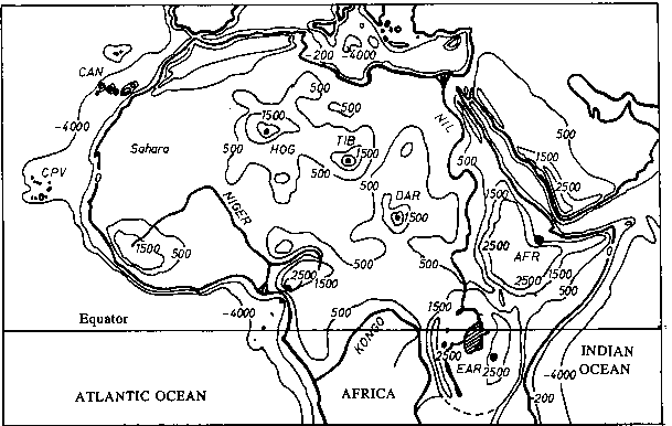
Fig. 5.
Smoothed regional topographic structures within the northern
part of Africa. The selected isolines outline the following
structures listed:
-4000 m refering to deep sea environment,
-200 m upper boundary of continental shelf,
0 coast line,
500 m transition from lowlands to higher lands and foot line
of swells,
1500 m highlands, central areas of regional swells,
2500 m highlands within regional swells in the vicinity of the
East African Rift
and central volcanic features within
swells.
The dots refer to identified centers of hot spots.
Regional topographic swells shown in Fig. 5 capped with basaltic volcanism can be found at Azores, Canary Islands, Cape Verde, Hoggar, Tibesti, Darfur, Cameroon, Afar/Ethiopia and East African Rift (Kenya, northern Tanzania and Virunga). All these hot spots are located on slow or not moving plates and therefore do not show a volcanic mountain range of progressive age. At Hoggar no recent volcanic activity has been reported according to Simkin and Siebert (1994). However, the topographical structure (Fig. 5) refers to an extinct or dormant hot spot location. Additionally, seismological events shown in the map of Simkin et al. (1989) demonstrate possible on-going future activity.
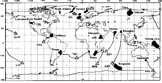
Fig. 6. Geographical distribution of major flood basalt provinces after Duncan and Richards (1991). Dotted lines link these provinces to hot spot locations, depicted as triangles.
Fig. 6 shows the distribution of the major flood basalt provinces. The link of the flood basalt provinces to a present hot spot location is indicated by the lines in Fig. 6. Iceland, Reunion, Galapagos, Louisville, Marion Prince Edward, Tristan, Kerguelen, Balleny, Afar, Yellowstone are related to a flood basalt province. Recent activity has been reported except from Louisville after Simkin and Siebert (1994) . The activity of Louisville has been decreased after Lonsdale (1988). Except Afar all listed flood basalt related hot spots do show a track of progressively aged mountains.
The world distribution of seamounts map in Craig and Sandwell (1991) shows well resolved seamount alignments in addition to the above listed hot spots downstream of Hawaii, Tahiti, Pitcairn, Marquesas, McDonald-Cook Austral Islands. Except from Marquesas and Pitcairn recent volcanic activity has been reported in Simkin and Siebert (1994). At Pitcairn recent activity has been reported by Stoffers et al. (1990). At Marquesas no recent activity is known (Desonie et al., 1993). All listed hot spots with a track but without a known connection to a flood basalt province are located on the fast moving Pacific plate (see Fig. 4).
After Detrick et al. (1986) the Bermuda hot spot is extinct for 20-30 Million years. Bermuda is surrounded by a large regional swell which refers to a mantle plume origin. The orientation of the swell cannot be explained with the drift of the North American plate (Richardson, 1991). This observation may refer to an altered lithosphere as suggested for being one possible swell mechanism by Crough (1983) left behind by a former plume support.
In addition to the above mentioned Pacific hot spots Easter Island has been classified a hot spot. This is in agreement with Sleep (1990) and Ito and Lin (1995). The hot spot of St. Helena is believed to be dormant or even already extinct due to the fact that no recent activity could be found in the region so far to my knowledge. At the southern end of the Louisville island chain there is no documented recent activity. Due to the long track of progressively aged seamounts leading back to the Ontong-Java flood basalt province Louisville is considered to be a recently extinct hot spot (Lonsdale, 1988; Watts et al., 1988). After Keating et al. (1984) activity has decreased also at the Caroline hot spot. After Sleep (1990) there presently is no obvious swell, too.
WARM SPOTS
All volcanic provinces that have not been mentioned in the chapter about hot spots are assumed to be of stress origin and therefore being classified as warm spots.
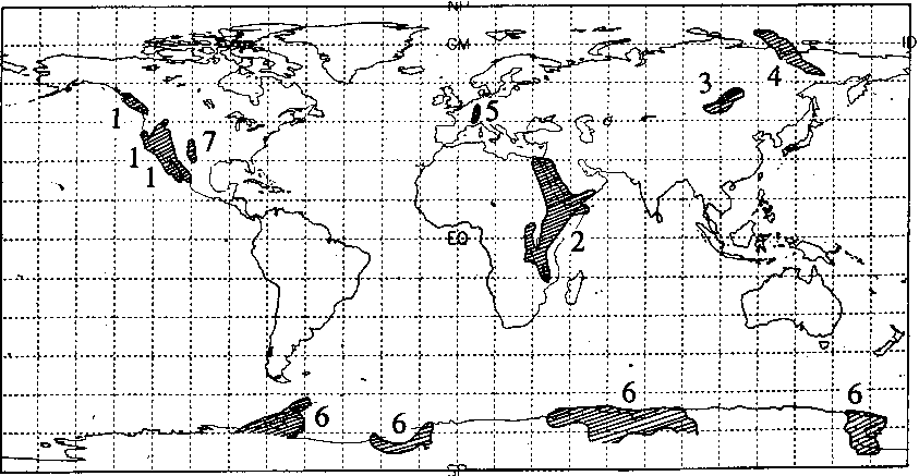
Fig. 7.
Geographical distribution of major continental riftogenes after
Nikolaev et al. (1984).
1: Basin and Range - Province,
2: East African Rift and Red Sea Rift systems,
3: Baikal-Rift,
4: Chersky-Rift (continuation of the Midatlantic Ridge into the
continent),
5: Rhine-Rhone-Rift system,
6: Antarctic Riftogenes,
7: Rio Grande Rift.
The first group contains the so-called riftogenic warm spots. Fig. 7 shows the geographical distribution of major continental riftogenes. After Fig. 7 only Yellowstone, Afar, and East African Rift are hot spots presently located in or linked to continental riftogens. Volcanic provinces, that are not classified as hot spots but lie within these areas are considered as riftogenic warm spots. These are listed in Tabs. 1 and 2 as WS-RIc. In addition to the continental riftogenic warm spots there are oceanic riftogenic warm spots. These are located on or very close to one of the oceanic ridges and are mentioned in Tabs. 1 and 2 by WS-RIo. They did not show any significant regional swell and/or progressively aged seamount chains.
An overview on the distribution of volcanism in the Basin and Range province is given in Suppe et al. (1975). Thorpe and Smith (1974) treats the Cenozoic volcanism of Africa that includes the East African Rift Valley volcanics. In Tab. 1 and Fig. 4 extensive geographical volcano clustering has been put together and identified as a single province.
Whereas Karsten and Delaney (1989) interpret the Bowie and Cobb volcanic provinces as being of mantle plume origin the geochemical results presented by Eaby et al. (1984) and Allan et al. (1988) suggest the origin not to be a mantle plume. In this study they are considered as a warm spot.
Bouvet has been classified a warm spot due to the following reasons. There is no excessive volcanism that should be expected on a hot spot dominated triple junction . Bouvet lies on/influences the same plates as Tristan. However, at Bouvet there are no track features reported that should be expected for all hot spots encountering the same plates.
Seamundsson (1986) interprets Jan Mayen as a southward extension of the Moins Ridge. The volcanism on the Revilla Gigedo Islands is interpreted as being of stress origin due to the intersection of the extinct Mathematican Ridge with the active East Pacific Rise after Mammerickx et al. (1988).
The second group contains the continental intraplate stress warm spots that occur in the hinterland of folded mountain ranges and in areas of terrane accretion. Volcanic provinces that lie within major orogenic belts and/or regions of terrane accretion are identified as intraplate stress warm spots. They are marked in Tabs. 1 and 2 as WS-ISc.
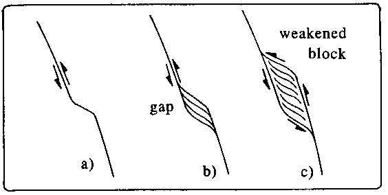
Fig. 8.
Possible mechanism of a warm spot origin. Continuous tectonic
stress causes material gaps along a curved fault line. These
gaps form zones of crustal/lithospheric weakness. Volcanism
occurs due to resulting decompressional melt production and/or
simply due to the higher vulnerability of the lithosphere to
magmatic power. The single steps of the process are:
a) A fault line has been developed due to stress fields.
b) Movement of the blocks along the curved fault line causes
gaps.
c) A weakened block results that promotes a warm spot location.
After Sykes (1978) and Black et al. (1985) postorogenic alkalic centers in Africa, Eurasia, and North America occur along preexisting zones of weakness and thus are often attributed to intraplate stress. One example is the Eifel warm spot. It is related (Sleep, 1990) to the stress of the Rhine Graben which can be interpreted as a result of the orogenesis of the Alpes.
The third group contains the plume influenced warm spots. These occur in a wider vicinity of hot spots as a consequence of a plume lithosphere interaction. They are also considered to be the result of excentric plume volcanism that is due to lithospheric zones of weakness. Tabs. 1 and 2 list this type by WS-EL (excentric location).
Especially the volcanics within the Sahara that surround the larger edifices classified as hot spots such as Tibesti are identified with this type of a warm spot. Thorpe and Smith (1974) give a good overview on the distribution of African volcanism. Sleep (1990) interprets Jan Mayen which has already been classified as a riftogenic warm spot as a part of the Iceland hot spot. Further examples that contain signatures of two classified types are treated at the end of this paragraph.
The fourth group contains fault cluster warm spots. This type of a volcanic province is identified if the literature suggests a weakness mechanism due to the occurence of major fault lines intersecting. Only very few of the volcanic provinces are classified in this manner. These are neither related to rift formation or plume lithosphere interactions nor to decompressional forces in the hinterland of folded mountain ranges. In Tabs. 1 and 2 they are referred to as WS-FC.
The Comores islands have been interpreted a warm spot originated by fault clustering similar to Etna according to Grimison and Chen (1988) who explained the Comores volcanics in terms of intraplate stress with respect to the East African Rift extension.
The fifth group consists of the oceanic intraplatestress warm spots. These may occur due to various processes such as flexure of the crust at major fracture zones. Tabs. 1 and 2 refer to them by the abbreviation WS-ISo. Batiza (1982) reported the existence of at least 30000 seamounts in the Pacific Ocean basin. The average thickness of oceanic crust is about 5-10 km, the average thickness of continental crust 20-70 km (e.g. Meissner, 1986). Therefore it is evident that oceanic crust is much more vulnerable to spotty volcanism supported from the deep than continental crust. Therefore some provinces classified as an oceanic intraplatestress warm spot may actually be a weak hot spot. An example might be San Felix or Juan Fernandez. However, after Sleep (1990) at Juan Fernandez and San Felix no obvious swells can be defined. This supports an intraplate stress origin which also is preferred by Mammerickx (1981). Additionally, from the location of known (submarine) volcanic eruptions within Juan Fernandez archipelago (Simkin and Siebert, 1994) can be concluded that there is no significant age progression in the archipelago.
After Crough (1983) only a small bouyancy flux and a small swell height is reported from Fernando and Trindade volcanic provinces which both are located at the end of a seamount chain. After Sleep (1990) there is no resolved geoid anomaly and no obvious broad topographic swell at Trindade, Discovery and Helena (weakened hot spot?). Moreover, locations like Vema or Discovery Seamounts (e.g. O'Conner and Duncan, 1990; Richards et al.,
1988) form single edifices or are integrated in a short seamount chain. All these structures may be short-lived hot spots or have been formed due to ridge-initiated intraplate stress.
There are numerous papers (e.g. Farley, 1995) who classify Samoa as being of plume origin. However, there is recent active volcanism reported (Simkin and Siebert, 1994; Johnson, 1984; McDougall, 1985) from various islands extending along a line of several hundreds of kilometers in length. Thus, there is no age progression which is a typical hot spot feature within the Pacific plate. The Samoa volcanic province is interpreted by Wright and White (1987) as a result of the crustal flexure due to the nearby subduction. It therefore is identified in the contrary to numerous hot spot lists as a warm spot in this paper. The absence of a large swell supports this classification. However, the close vicinity of the subduction may suppress or alterate typical hot spot signatures.
The Atlantis-Meteor seamount group forms a larger complex within the Atlantic Ocean basin. After Weigel et al. (1990) this complex does not show any recent activity at all. Verhoef and Collette (1983) attributed a minor plate boundary to this complex. This can be interpreted as a form of intraplate stress. However, in the contrary to this study O'Connor and Duncan (1990) link the Atlantis-Meteor Seamount group to the New England Seamounts and thus conclude a mantle plume origin for Great Meteor (regarded as extinct in this paper). There are plots in the literature that list Madeira a single volcanic province. According to this classification Madeira is considered as a part of the extensive volcanic province of the Canary Islands hot spot. This is supported by the geoid map of Jung and Rabinowitz (1986) on which Madeira is included in the Canary anomaly that itself is obscured by the close vicinity of the African margin.
A special kind of riftogenic warm spots are volcanic provinces that are located on-ridge (or off-ridge close to the ridge) and considered to be linked to a nearby hot spot location. The location of St. Paul and Amsterdam Islands is believed to be linked by an asthenospheric channeling flow to the Kerguelen hot spot after Morgan (1978). The same author links the Balleny volcanism with the Erebus hot spot and Rodriguez Island to the Reunion hot spot. However, the Balleny volcanism is linked to the Tasman flood basalts after Duncan and Richards (1991). Therefore it is considered to be a hot spot location. This might be linked to Mt. Erebus volcanism. Castillo et al. (1988) interpreted the Cocos Islands as a feature linked to the Galapagos hot spot. Another link between to locations is reported by Morgan (1978) between Ascension and St. Helena.
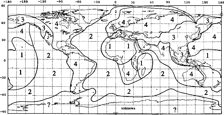
Fig. 9.
Geographical classification of regions that outline
relationships and interactions between hot spots, warm spots and
rifting processes.
1 - Areas of intraplate volcanic provinces (occurrence of hot
spots and warm spots),
2 - Areas of interactions between hot spots and rifting and
occurence of warm spots,
3 - Areas that are characterized by collisional regimes such as
terrane accretion and the regional hinterland of subduction
zones.
4 - Areas free of hot spots and warm spots.
A complicated situation is also found in Australia and New Zealand. The volcanism of South East Australia is linked to a mantle plume by McDougall and Duncan (1988) who identified three "hot spot" tracks two of them within the Tasman Sea. The latter refer to a small hot spot origin for the Tasmantid volcanics. After Sleep (1990) these can also be attributed to intraplate stress. Adams (1981) wrote of late Cenozoic volcanism sites spread over the Campbell Plateau and the South Island of New Zealand which is not interpreted as being of plume but of another kind of mantle upwelling origin. However, the extensive distribution of this volcanism suggests this area to be classified a warm spot of stress origin.
GEOGRAPHICAL CONCLUSIONS
Figs. 9 and 10 illustrate the classification of volcanic provinces geographically. Fig. 9 shows the relation of volcanic provinces and global tectonic features. All volcanic provinces classified are closely related to divergent processes due to the basaltic signature of their lavas. After Fig. 9 the surface of the Earth can be subdivided into four regions that show a different character with respect to the occurence of volcanic provinces. The boundaries drawn in Fig. 9 between the different regions have to be considered as indicators for gradual changes with respect to the occurence of spotty volcanism on both sides of such a boundary.
Region (1) which contains mainly the interior of the Pacific and African plate is characterized by pure intraplate volcanism and contains hot spots and warm spots. The Pacific area of region type (1) is dominated by the hot spot of Hawaii and the south Pacific hot spot province consisting of e.g. Tahiti, McDonald, Pitcairn. The African area includes as major features the hot spots in the Sahara Hoggar(dormant), Tibesti and Darfur as well as the Cape Verde and Canary Islands, Afar, the East African Rift Volcanic Province and Cameroon. In addition to these there is the Mascarene area that is dominated by the Reunion hot spot and the Comores warm spot.
There are resemblances in the character of region (1) with similar regions on the terrestrial planets of Mars and Venus. The continental areas of region (1), especially the Sahara hot spot family, can be compared with the volcanoes of the Tharsis province on Mars. The oceanic parts of region (1) are comparable to the basaltic surface of Venus. This comparison is even more striking with respect to the age and thicknesses of the lithospheres (Janle and Meissner, 1986; Francis, 1993) involved. The thin and younger Venusian lithosphere is much more vulnerable to spotty volcanism than the thick and old Martian lithosphere.
Region (2) is defined by areas that are characterized by hot spots interacting with oceanic ridges and continental rifts. The East African Rift System is included in this type. The geographical center line corresponds to the divergent plate boundaries. Hot spots and warm spots that are not located in the geographical center line area of region (2) may interact with the ridge system. Propagation and/or dead ends of rifting can be observed at the northern edge of the Red Sea, the southern end of the East African Rift and in the Chersky Rift area outlined as sharp edges in the boundary line of region (2).
In the west of North America region (2) is bounded by region (3). This area presently is characterized by an active oceanic ridge is going to be subducted underneath a continent. Here, the westward drifting American plate overruns the Pacific plate. The Baja California and Basin and Range province marks the transition zone between rifting and subduction related forces. Yellowstone hot spot withstands this subduction process due to its mantle plume origin manifested in the occurence of the Columbia River flood basalt track. Possibly, Yellowstone was an "Iceland" of the East Pacific Rise in the geological history.
Region (3) is defined by the areas that have been processed by terrane accretion after Jones et al. (1985) on the one hand and the hinterland of folded mountains ranges on the other hand. No hot spots except Yellowstone which lies at the above discussed transition between regions (2) and (3) can be found in region (3). For after Sykes (1978) this region contains especially those volcanic provinces that can be related to intraplate stress due to distant subduction processes all these are
included in the classified warm spots in this paper. Molnar and Tapponnier (1975) interpret the Baikal Rift as a consequence of the collision of India into Asia to which I do agree. However, Rasskazov (1991) considers Baikal a hot spot. The Baikal Rift location is identified with the volcanoes located south west of Lake Baikal (Sajan province). After Logatchev et al. (1983) this volcanic province correlates with passive rift structures and therefore has been identified a warm spot.
Miyashiro (1986) also recognized the nature of east Asian and Australian spotty volcanism being not of a simple plume origin by introducing the term "hot regions". However, I disagree to the conclusions (migration of broad hot regions) drawn by Miyashiro (1986).
In region (4) there are no hot spots and no warm spots. No volcanic provinces that are in recent hot age or in a dormant stage could be found in the literature. An exception might be Bermuda hot spot. Because of its well outlined swell (Crough, 1978; Detrick et al., 1986) it is listed in the hot spot catalogues of Monnereau and Cazenave (1990) and Duncan and Richards (1991). However, Bermuda does not show any active volcanism for 20 to 30 million years after Detrick et al. (1986). Therefore the Bermuda hot spot is considered extinct and consequently not included in the present geographical situation. Region (4) contains old cratons (Jordan, 1985) and thick lithosphere (Pollack et al., 1981) except in Antarctica and Africa. Regions that are attributed to former subduction processes after Chase and Sprowl (1983) are included in region type (4).
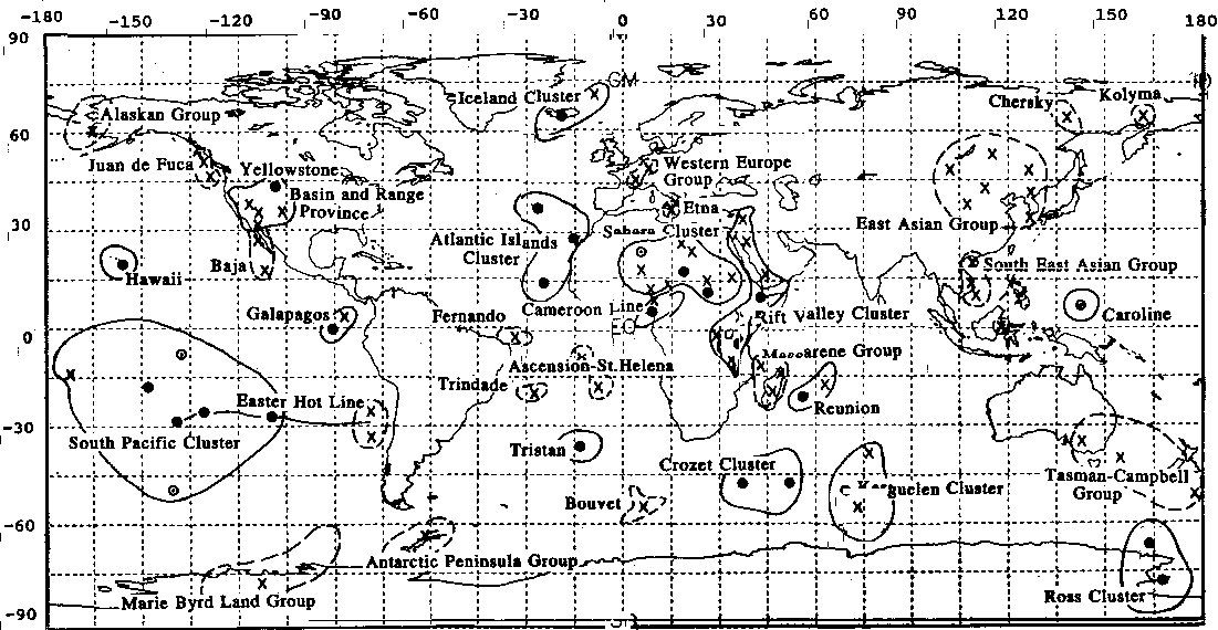
Fig. 10. Clustering and grouping of hot spots and warm spots. Clusters describe a hot spot dominated region, groups describe regions with an extensive occurence of individual warm spots. These themselves often contain areas of regionally widespread volcanic centers.
The geographical distribution of hot spots shows clustering and grouping. Fig. 10 depicts two prominent hot spot groups of global size. These are the African and the Pacific hemispheric groups which have already been reported by Crough and Jurdy (1980). Their geoid correlation can even be improved by omitting the extinct hot spot of Bermuda. The two hemispheric groups are separated by two parts of region type (4) as depicted in Fig. 9. These spot free areas have been explained by Chase and Sprowl (1983) as subduction influenced 100 million years ago. Here, cool subducted and now sinking material may suppress possible plume activities. Geographically these areas affected by former subduction processes are eastern America and Indo-Eurasia.
The African hot spots are all located within a slow moving plate whereas the Pacific hot spots all are located on fast moving plates. The Pacific hot spots can be subdivided into four groups. First, there is the isolated located hot spot of Hawaii which is characterized by recent strong and persistent volcanism. Second, there is the South Pacific hot spot cluster which is formed by McDonald, Pitcairn, and Tahiti. McNutt and Fisher (1987) attributed the term "Superswell" to the hot spot cluster containing Easter Island, Pitcairn, Marquesas, McDonald, Tahiti. However, Marquesas is considered a dormant hot spot. Desonie et al. (1993) call the Marquesas a weak hot spot and write that there is no known site of active volcanism. A superswell can be caused either by a close spacing of single plumes and therefore overlapping or by a large plume structure called a megaplume. The term superplume has already been applied to a strong starting plume by Larson (1991). Third, there are volcanic provinces in the eastern part of the Pacific that have been discussed as "hot spots". These are Easter Island, San Felix, and Juan Fernandez. Bonatti et al. (1977) call the group of Easter Island, San Felix, Juan Fernandez, Pitcairn and McDonald a hot line which does not necessarily contradict the classification of individual volcanic provinces within this line
to be a hot spot or a warm spot, respectively. Fourth, there is the Galapagos hot spot which interacts with a ridge system and is linked to the Caribbean flood basalt province according to Fig. 6.
In addition to the distribution of hot spots warm spots occur along the major divergent plate boundaries and adjacent to these as outlined already as region (2) in Fig. 9. Additionally a regional clustering of warm spots that are intraplate stress related is documented in eastern Asia. Here, no signatures typical for mantle plume origins could be identified. Furthermore, there is no riftogenic environment after Fig. 7 (except Baikal which has been interpreted a response of the Indo-Asia collision after Molnar and Tapponnier (1975)). However, there is a regime of terrane accretion and collision of large plates in distance from the reported alkalic warm spot centers. Thus, these are attributed to the regional stress field. Examples also in relation to the opening of the South China Sea are the warm spots of Cu-Lao Re and Cendres islands (Vietnam).
GENERAL DISCUSSION
The main result of this paper is that only a few of the numerous isolated volcanic provinces on Earth can be associated with mantle plumes and thus can be identified as hot spots. All the other identified volcanic provinces that have been called "hot spots" by the cited references have to be explained in a different way. The given classification suggests a way to distinguish between various processes. The present hot spot distribution not necessarily represents the plume distribution. There may be plumes that have not been yet discovered due to the fact they failed to penetrate the lithosphere.
"Hot spot" volcanism is a common feature on all earth-like planets. Spotty volcanism has been reported from Venus (e.g. Stofan and Saunders, 1990), from Mars (e.g. Francis, 1993) and from the Jovian moon Io (e.g. McEwen et al., 1985). To my knowledge dominating plate tectonical structures could not been found so far on one of these planets. The similarities of region (1) with Mars and Venus support the conclusion that hot spot volcanism is the common way of heat loss for a planet. A very special state of the lithosphere on Earth has initiated the powerful process of plate tectonics as a secondary mechanism of heat loss. This mechanism, however, meanwhile yields almost 100% of the heat release (Solomon and Head, 1982) and thus has long become the first mechanism. After Mian and Tozer (1990) the liquid water layer on Earth is responsible for creating plate tectonical movements as the major source of heat release.
Only the hot spots identified in this paper classify for being evaluated with respect to plate motions, reference schemes and other conclusions drawn from a hot spot distribution. Fig. 9 reveals that the distribution of volcanic provinces on Earth not related to plate tectonical forces is not a statistical one. This is particularily true for the hot spot distribution. Distribution statistics like the one of Stefanik and Jurdy (1984) that do not take into account the possibility of various source mechanisms for the treated volcanic provinces are too simple. Conclusions on global phenomena drawn from this kind of investigations have to be considered extremely carefully.
Only those volcanic provinces that have been identified as a hot spot have to be considered in discussions about hot spot rifting interactions. Campbell et al. (1989), Richards et al. (1988) and
Sleep (1990) consider plumes a secondary convection scheme that is independent from global convection systems. However, White and McKenzie (1989) integrate plumes into the global convection scheme. Because I fail to imagine an undisturbed superposition of plumes with another "global" convection I personally also cannot believe in the existence of two convection patterns that do not interact. Spohn and Schubert (1982) point out that spotty support from the deep does control the rift/ridge distribution pattern. However, while also Sengor and Burke (1978) favor a hot spot rifting interaction Hill (1991) refuses such a hot spot rift interaction. Fig. 9 reveals that there are hot spots obviously interacting with rift/ridge features such as AFR and ICL. Other hot spots do not interact with a ridge at all. Thus, it is possible to conclude that hot spots can initiate (depending on the regional tectonical stress situation at the time of hot spot formation) but do not necessarily do initiate and thus control rifting.
The hot spot reference frame frequently cited in the literature assumes long-living hot spot structures on the one hand and a negligible movement of the plumes supporting present hot spot locations with respect to each other on the other hand. However, especially in the Pacific there is evidence that plume activity changes in geological times. This is documented by the decreasing activity of the Louisville hot spot (Lonsdale, 1988) that once started its hot age by erupting the Ontong-Java flood basalts. Furthermore, McNutt et al. (1990) interpret the Darwin Rise which is comparable in extent to the present superswell in the South Pacific as a consequence of a massive plume activity in the Cretaceous.
In addition to these examples Coffin and Eldholm (1993) list a plume age for Hawaii of 70 Ma, Upton (1988) lists an Icelandic plume age of 60 Ma, and O'Connor and le Roex (1992) claim the Tristan da Cunha plume as 120 Ma old. Thus, hot spot support actually is often persistent. However, it is not there through all time scales. Another example may be all Pacific hot spots that neither do backtrack to a flood basalt province nor have a track that extends back to a subduction front. Shorter island chains are especially found in the South Pacific, e.g. Tahiti.
The arrival of a strong new plume at the base of the lithosphere may generate flood basalt provinces. Coffin and Eldholm (1993) point out that these then are generated within the short peroid of only a few million years. This time scale has to be distinguished from the steady-state character of long-living plumes after such an initial event. The world flood basalt distribution compiled by Coffin and Eldholm (1994) is much more complete than the one depicted in Fig. 6 but it obscures relationships between classified volcanic provinces and flood basalts.
The use of the hot spot reference frame must be restricted to the volcanic provinces identified as hot spots. However, the stationarity of the plume support has been frequently questioned (Anderson et al., 1992; Molnar and Stock (1987); Molnar and Atwater, 1973). Minster et al. (1974) and Minster and Jordan (1978) do not see significant relative movement between the individual plume centers. Duncan and Richards (1991), however, confirm stationary plume centers in the Pacific and elsewhere but found a relative movement of the Pacific plume centers with respect to other plumes. They conclude either plumes are not stationary or there must be an unknown plate boundary in the Antarctic.
ACKNOWLEDGMENTS
When starting his PhD-studies about hot spots in general and Hawaii in particular the author realized quite contradictionary opinions about hot spots in the literature. This work suggests a possible classification of identified "hot spots". It became part of the PhD-Thesis of the author who wishes to thank Prof. P. Janle and Prof. R. Meissner for helpful discussions during his PhD-studies and Dr. J. Fritsch for constructive comments.
REFERENCES
Adams, C. J., 1981, Migration of late Cenozoic volcanism in the South Island of New Zealand and the Campbell Plateau, Nature, 294, p. 153-155.
Allan, J. F., Cousens, B. L., Chase, R. L., Gorton., M. P., and Michael, P. J., 1988, Alkaline lavas from the Tuzo Wilson seamounts, NE Pacific: volcanism at a complex ridge-transform intersection (abstract); EOS Trans. AGU, 69, p. 1503.
Batiza, R., 1982, Abundances, distribution and sizes of volcanoes in the Pacific Ocean and implications for the origin of non-hotspot volcanoes, Earth Planet. Sci. Lett., 60, p. 195- 206.
Black, R., Lameyre, L., and Bonin, B., 1985, The structural setting of alkaline complexes, J. Afr. Earth Sci., 3, p. 5-16.
Bonatti, E., Harrison, C. G. A., Fischer, D. E., Honnorez, J., Schilling, J. G., Stipp, J. J., and Zentelli, M., 1977, Easter volcanic chain (southeast Pacific): a mantle hot line, J. Geophys. Res., 82, p. 2457-2478.
Burke, K. C., and Wilson, J. T., 1976, Hot spots on the Earth's surface, Scientific American, 235, p. 46-57.
Campbell, P., Griffiths, R. W., and Hill, R. I., 1989, Melting in an Archean mantle plume: heads and its basalts, tails and its komatiites, Nature, 339, p. 697-699.
Castillo, P., Batiza, R., Vanko, D., Malavassi, E., Barquero, J., and Fernandez, E., 1988, Anomalously young volcanoes on old hot-spot traces, I, Geology and petrology of Cocos Island, Geol. Soc. Am. Bull., 100, p. 1400-1414.
Chase, C. G., and Sprowl, D. R., 1983, The modern geoid and ancient plate boundaries, Earth Planet. Sci. Lett., 62, p. 314- 320.
Coffin, M. F., and Eldholm, O., 1993, Large igneous provinces, Sci. Am., 269, No. 4, p. 26-33.
Coffin, M. F., and Eldholm, O., 1994, Large igneous provinces: crustal structure, dimensiones, and external consequences, Reviews of Geophysics, 32, 1, p. 1-36.
Courtney, R. C., and White, R. S., 1986, Anomalous heat flow and geoid across the Cape Verde Rise: evidence for dynamic support from a thermal plume in the mantle, Geophys. J. R. Astron. Soc., 87, p. 815-868.
Craig, C. H., and Sandwell, D. T., 1988, Global distribution of seamounts from SEASAT profiles, J. Geophys. Res., 93, B 9, p. 10408-10420.
Crough, S. T., 1978, Thermal origin of mid-plate hot spot swells, Geophys. J. R. Astron. Soc., 55, p. 451-469.
Crough, S. T., 1983, Hotspot swells, Ann. Rev., Earth Planet Sci., 11, p. 165-193.
Crough, S. T., and Jurdy, D. M., 1980, Subducted lithosphere, hot-spots, and the geoid, Earth Planet Sci. Lett., 48, p. 15-22.
Desonie D. L., Duncan, R. A., Natland, J. H., 1993, Temporal and geochemical variability of volcanic products of the Marquesas hotspot, J. Geophys. Res., B, 98, 10, p. 17649-17665.
Detrick, R. S., von Herzen, R. P., Parsons, B., Sandwell, D., and Dougherty, M., 1986, Heat flow observations on the Bermuda Rise and thermal models of midplate swells, J. Geophys. Res., 91, p. 3701-3723.
Duncan, R. A., and Richards, M. A., 1991, Hotspots, mantle plumes, flood basalts, and true polar wander, Rev. Geophys., 29, p. 31-50.
Eaby, J., Clague, D. A., and Delaney, J. R., 1984, Sr isotopic variations along the Juan de Fuca ridge, J. Geophys. Res., 89, p. 7883-7890.
Farley, K. A., 1995, Rapid cycling of subducted sediments into the Samoan mantle plume, Geology, 23, 6, p. 531-534.
Francis, P., 1993, Volcanoes, a planetary perspective, Oxford University Press Inc., New York.
Grimison, N. L., and Chen, W.-P., 1988, Earthquakes in the Davie Ridge-Madagascar region and the southern Nubian-Somalian plate boundary, J. Geophys. Res., 93, p. 10439-10450.
Hill, R. I., 1991, Starting plumes and continental break-up, Earth Planet. Sci. Lett., 104, p. 398-416.
Ito, Garrett, and Lin, Jian, 1995, Oceanic spreading center- hotspot interactions, constraints from along-isochron bathymetric and gravity anomalies, Geology, 23, 7, p. 657-660.
Janle, P., and Meissner, R., 1986, Structure and evolution of the terrestrial planets, Surveys in Geophysics, 8, p. 107-186.
Johnson, R. H., 1984, Exploration of the submarine volcanoes in the South Pacific, Nat. Geogr. Soc. Rep., 16, p. 405-419.
Jones, D. L., Cox, A., Coney, P., and Beck, M., 1985, Nordamerika: ein Kontinent setzt Kruste an, in: Ozeane und Kontinente, 3. Aufl., Spektrum-der-Wissenschafts- Verlagsgesellschaft, Heidelberg, p. 182-198.
Jordan, T. H., 1985, Die Tiefenstruktur der Kontinente, in: Ozeane und Kontinente, 3. Aufl., Spektrum-der-Wissenschaft- Verlagsgesellschaft, Heidelberg, p. 95-105.
Jung, W.-Y., and Rabinowitz, P. D., 1986, Residual geoid anomalies of the North Atlantic Ocean and their tectonic implications, J. Geophys. Res., 91, p. 10383-10397.
Karsten, J. L., and Delaney, J. R., 1989, Hot spot-ridge crest convergence in the northeast Pacific, J. Geophys. Res., 94, p. 700-712.
Keating, B. H., Mattey, D. P., Helsley, C. E., Naughton, J. J., and Epp, D., 1984, Evidence for a hotspot origin of the Caroline islands, J. Geophys. Res., 89, p. 9937-9948.
Larson, R. L., 1991, Latest pulse of Earth: evidence for a mid- Cretaceous superplume, Geology, 19, p. 547-550.
Logatchev, N. A., Zorin, Y. A., and Rogozhina, V. A., 1983, Baikal rift: active or passive? - Comparison of the Baikal and Kenya rift zones, in: Processes of continental rifting, ed. by P. Morgan and B. H. Baker, Tectonophysics, 94, p. 223-240.
Lonsdale, P., 1988, Geography and history of the Louisville hot- spot chain in the southwest Pacific, J. Geophys. Res., 93, p. 3078-3104.
Mammerickx, J., 1981, Depth anomalies in the Pacific: active, fossil and precursor, Earth Planet. Sci. Lett., 53, p. 147-157.
Mammerickx, J., Naar, D. F., and Tyce, R. L., 1988, The Mathematician paleoplate, J. Geophys. Res., 93, p. 3025-3040.
Marzocchi, W., and Mulargia, F., 1993, Patterns of hot spot volcanism, J. Geophys. Res., 98, B8, p. 14029-14039.
McDougall, I., and Duncan, R. A., 1988, Age progressive volcanism in the Tasmantid seamounts, Earth Planet Sci. Lett., 89, p. 207-220.
McEwen, A. S., Matson, D. L., Johnson, T. V., and Soderblom, L. A., 1985, Volcanic hot spots on Io, correlation with low-albedo calderas, J. Geophys. Res., 90, 14, p. 12345-12379.
McNutt, M., and Fisher, K., 1987, The South Pacific superswell, in: Seamounts, islands, and atolls, Geophys. Monogr. Ser. 43, ed. by B. Keating and R. Batiza, p. 25-34, AGU, Washington, DC.
McNutt, M. K., Winterer, E. L., Sager, W. W., Natland, J. H., and Ito, G., 1990, The Darwin Rise: a Cretaceous superswell?, Geophys. Res. Lett., 17, p. 1101-1104.
Meissner, R., 1986, The continental crust, a geophysical approach, International Geophys. Ser., 34, Academic Press Inc., San Diego.
Mian, Z. U., and Tozer, D. C., 1990, No water, no plate tectonics: convection heat transfer and the planetary surfaces of Venus and Earth, Terra Nova, 2, 5, p. 455-459.
Minster, J. B., Jordan, T. H., Molnar, P., and Haines, E., 1974, Numerical modeling of instantaneous plate motions, Geophys. J. R. Astron. Soc., 36, p. 541-576.
Minster, J. B., and Jordan, T. H., 1978, Present-day plate motions, J. Geophys. Res., 83, p. 5331-5354.
Miyashiro, A., 1986, Hot regions and the origin of marginal basins in the western Pacific, Tectonophysics, 122, 3-4, p. 195- 216.
Molnar, P., and Atwater, T., 1973, Relative motions of hotspots in the mantle, Nature, 246, p. 288-291.
Molnar, P., and Stock, J., 1987, Relative motions of hot spots in the Pacific, Atlantic and Indian Oceans since late Cretaceous time, Nature, 327, p. 587-591.
Molnar, P., and Tapponnier, P., 1975, Cenozoic tectonics of Asia: effects of a continental collision, Science, 189, p. 419- 426.
Monnereau, M., and Cazenave, A., 1990, Depth and geoid anomalies over oceanic hotspot swells: a global survey, J. Geophys. Res., 95, B 10, p. 15429-15438.
Morgan, W. J., 1971, Convection plumes in the lower mantle, Nature, 230, p. 42-43.
Morgan, W. J., 1972, Deep mantle convection plumes and plate motions, Am. Assoc. Pet. Geol. Bull., 56, p. 203-213.
Morgan, W. J., 1978, Rodriguez, Darwin, Amsterdam, ..., a second type of hotspot island, J. Geophys. Res., 83, p. 5355-5360.
Nikolaev, N. I., Kuznetskov, Yu. Ya., and Naimark, A. A., 1984, Neotectonic map of the world, 1:15 Mio., Ministerstvo Geologii, SSSR, Moskva.
O'Connor, J. M., and Duncan, R. A., 1990, Evolution of the Walvis Ridge-Rio Grande Rise hot spot system: implications for African and South American plate motions over plumes, J. Geophys. Res., 95, B 11, p. 17475-17502.
O'Connor, J. M., and le Roex, A. P., 1992, South Atlantic hot spot-plume systems, 1, distribution of volcanism in time and space, Earth Planet. Sci. Lett., 113, p. 343-364.
Pichler, H., 1985, Einfuehrung, in : Vulkanismus, Spektrum-der- Wissenschaft-Verlag, Heidelberg, p. 7-15.
Pollack, H. N., Gass, I. G., Thorpe, R. S., and Chapman, D. S., 1981, On the vulnerability of lithospheric plates to midplate volcanism: reply to comments by P. R. Vogt, J. Geophys. Res., 86, p. 961-966.
Pollack, H. N., Gass, I. G., Thorpe, R. S., and Chapman, D. S., 1983, On the vulnerability of lithospheric plates to midplate volcanism: reply to comments by M. A. Summerfield, J. Geophys. Res., 88, p. 1251-1254.
Rasskazov, S. V., 1991, Hot spot and structure of the western Baikal rift system, Soviet geology and geophysics, 32, 9, p. 63- 70.
Richards, M. A., Hager, B. H., and Sleep, N. H., 1988, Dynamically supported geoid highs over hotspots: observation and theory, J. Geophys. Res., 93, B7, p. 7690-7708.
Richardson, R. M., 1991, Bermuda stretches a point, Nature, 350, p. 655-656.
Saemundsson, K., 1986, Subaerial volcanism in the western North Atlantic; in: The geology of North America, M, The western North Atlantic Region, ed. by P. R. Vogt and B. E. Tucholke, p. 69-86, Geology Society America, Boulder, Colo.
Schmidt, P., 1994, Klassifizierung der Hot Spots und die Dichtestruktur des Hawaiianischen Mantel-Plume-Hot-Spots (in German), PhD-thesis, Christian-Albrechts-University, Kiel, Germany.
Schmidt, P., 1996, Hot spots and warm spots - volcanic provinces of different origin, EGS XXIth General Assembly, Den Haag (Abstract).
Sengor, A. M. C., and Burke, K., 1978, Relative timing of rifting and volcanism on Earth and its tectonic implications, Geophys. Res. Lett., 5, p. 419-421.
Shaw, H. R., and Jackson, E. D., 1973, Linear island chains in the Pacific: results of thermal plumes or gravitational anchors?, J. Geophys. Res., 78, p. 8634-8652.
Simkin, T., and Siebert, L., 1994, Volcanoes of the world, 2nd edition, Smithsonian institution, Geoscience Press, Tucson, Arizona.
Simkin, T., Tilling, R. I., Taggart, J. N., Jones, W. J., and Spall, H., 1989, This dynamic planet: world map of volcanoes, earthquakes, and plate tectonics; to commemorate the 28th International Geological Congress, Washington, D. C.
Sleep, N. H., 1974, Segregation of magma from a mostly crystalline mush, Geol. Soc. Am. Bull., 85, p. 1225-1232.
Sleep, N. H., 1984, Tapping of magmas from ubiquitous mantle heterogeneities: an alternative to mantle plumes?, J. Geophys. Res., 89, B 12, p. 10029-10041.
Sleep, N. H., 1990, Hotspots and mantle plumes: some phenomenology, J. Geophys. Res., 95, B 5, p. 6715-6736.
Solomon, S. C., and Head, J. W., 1982, Mechanism for lithospheric heat transport on Venus: implications for tectonic style and volcanism, J. Geophys. Res., 87, p. 9236-9246.
Solomon, S. C., and Sleep, N. H., 1974, Some models for absolute plate motions, J. Geophys. Res., 93, 2899-2918.
Spohn, T., and Schubert, G., 1982, Convective thinning of the lithosphere: a mechanism for the initiation of continental rifting, J. Geophys. Res., 87, p. 4669-4681.
Stefanik, M., and Jurdy, D. M., 1984, The distribution of hot spots, J. Geophys. Res., 89, B 12, p. 9919-9925.
Stofan, E. R., and Saunders, R. S., 1990, Geologic evidence of hotspot activity on Venus, predictions for Magellan, Geophys. Res. Lett., 17, 9, p. 1377-1380.
Stoffers, P., et al., 1990, Active Pitcairn hot spot found, Marine Geology, 95, p. 51-55.
Suppe, J., Powell, C., and Berry, R., 1975, Regional topography, seismicity, Quaternary volcanism, and the present-day tectonics of the western United States, Am. J. Sci., 275 A, p. 397-436.
Sykes, L. R., 1978, Intraplate seismicity, reactivation of preexisting zones of weakness, alkaline magmatism and other tectonism post-dating continental fragmentation, Rev. Geophys., 16, p. 621-688.
Thorpe, R. S., and Smith, K., 1974, Distribution of Cenozoic volcanism in Africa, Earth Planet Sci. Lett., 22, p. 91-95.
Turcotte, D. L., and Oxburgh, E. R., 1973, Mid-plate tectonics, Nature, 244, p. 337-339.
Turcotte, D. L., and Oxburgh, E. R., 1976, Stress accumulation in the lithosphere, Tectonophysics, 35, p. 183-199.
Upton, B. G. J., 1988, History of Tertiary igneous activity in the N Atlantic borderlands, in: Early Tertiary volcanism and the opening of the NE Atlantic, ed. by Morton, A. C., and Parson, M. L., Geol. Soc. Spec. Publ., London, 39, p. 429-453.
Verhoef, J., and Collette, B. J., 1983, A tear fault system beneath the Atlantis-Meteor seamount group, Annales Geophysicae, 1, 3, p. 199-206.
Vogt, P. R., 1981, On the applicability of thermal conduction models to mid-plate volcanism: comments on a paper by Gass et al., J. Geophys. Res., 86, p. 950-960.
Watts, A. B., Weissel, J. K., Duncan, R. A., and Larson, R. L., 1988, Origin of the Louisville ridge and its relationship to the Eltanin fracture zone system, J. Geophys. Res., 93, p. 3051- 3077.
Weigel, W., et al., 1990, Bericht ueber die METEOR-Expedition M12/2, University of Hamburg, Germany.
White, R., and McKenzie, D., 1989, Magmatism at rift zones: the generation of volcanic continental margins and flood basalts, J. Geophys. Res., 94, B 6, p. 7685-7729.
Wilson, J. T., 1963, A possible origin of the Hawaiian Islands, Can. J. Phys., 41, p. 863-870.
Wilson, J. T., 1973, Mantle plumes and plate motions, Tectonophysics, 19, p. 149-164.
Wright, E., and White, W. M., 1987, The origin of Samoa: new evidence from Sr, Nd and Pb isotopes, Earth Planet. Sci. Lett., 81, p. 151-162.
zur BegrüßungsseiteYou are counted visitor ![]() since 29th Dec 1998!
since 29th Dec 1998!